Monday, January 31, 2011

Huaraz, Peru

We decided to take a day off today to do laundry and kick back. Our hotel being so nice and affordable had a major influence in the decision making. We're in what I would consider a high 3 or even 4 star place that has hot water and toilet seats. Wahoo! We get our own room with breakfast for 48 soles each. At about 2.7 soles to the dollar thats pretty good.
We just wandered around town today and took a few pictures. Huaraz is a center for trekking and climbing in the mountains of the Cordillera Blanca. There are supposed to be more than 20 mountain peaks near here that are over 6000 meters (20,000 ft). It's the wet time of year here so it's the low season for tourists. That's good for us. This morning the mountains around town were covered with a fresh dusting of snow but they were hidden by cloud most of the day. Right now the sky is black and we're getting thunder and lightning. Must be the pattern as that's what it was doing when we showed up yesterday. Here's a few pics from the day.
This guy had a monkey trained to dance.

It seems like the streets are always bustling.


Finally managed a few shots of some ladies in traditional dress. The clothing varies by region. In one area of Ecuador all the women we wearing the same kind of white hat and black clothing.

There are a lot of entrepreneurs here. This guy was building doors from scratch in his tiny shop.

Some peaks of the Cordillera Blanca north of Huaraz.


Later...

Sunday, January 30, 2011

Rio Santa, Peru

When we we're riding into Piura on Friday night we noticed a lot of people riding in the back of these big open trucks and small crowds of people on the side of the highway. A lot of people. It looked like they were coming to or from work on these huge farms in the area. There were also many trucks loading and unloading various kinds of produce at various places along the highway.  Anyways, it's obvious agriculture is big business here and it employs a huge number of people. There were big shanty towns on both sides of the highway so I suspect most of these workers are migrant. Their living conditions didn't look that great as some of the shelters were palm thatch walls and had no roof. There wouldn't have been any plumbing either. We were warned about safety in this area and this is probably part of the reason. You know...desperate people, desperate acts. I'm not judging or anything. It's just interesting to see.
On Saturday morning we left Piura and headed across the Desierto de Sechura. It's about 200 kilometers from Piura to Chiclayo and it's all desert. Unfortunately, at least from the highway, the beauty of the desert is ruined by the sight and smell of garbage along the side of the road. It looks like the garbage gets trucked out from the city and just dumped in the desert, even right along the highway. It's hard to believe nobody can see how wrong this looks. It was still nice to see the desert but it would have been nicer without the garbage. When we got south of Trujillo we hit the coast and the sides of the highways became less cluttered with trash. Good thing. It was getting depressing.
Desierto de Sechura

A major mode of transport here. Everywhere here. We saw one heaped about three times the height of this. Unbelievable.

This truckload wasn't bad. We saw one with a load that overhung about a third of our lane.


Lots of dunes driven by the wind off the Pacific.

Yeah, it was beautiful.

We were planning to leave the coast the next day and head inland so we stopped at Santa. It's a very small town on the coast near the mouth of Rio Santa. For such a small town it had quite a few hostels and we found very affordable accommodation. It was a really nice town but you couldn't tell from the highway. That's one of the things we've found along the way. Sometimes you have to take a closer look. You know...the book and the cover thing. We were able to park the bikes in a very nice garage where Neil changed a couple of spark plugs. His bike has been farting a bit so he thought he might have a cracked plug from the overheating in Acapulco.
Nicer than Wade's garage. Real ceramic tile. Sorry buddy.

I'm thinking of buying a toilet seat and carrying it like a spare tire.

This morning we were on the road before 7:30 and had an incredible ride up the Santa Valley to Huaraz. I think it was about 260 km but it took us until 1:30 or so and included about 100 km of rough gravel. Words don't do it justice so I won't try.
Rice paddies.


They don't let just any idiots up here. Only some.

This is for my daughter Meagan. Cool folds in the rock.

A village along the way.

Where's Neil?

Another one for Meg.

The horizontal line is the road.

There were a few coal mines like this.

There were so many tunnels I didn't count. They were all a narrow single lane. Some were quite long and all were dark. Some had buses in them. That was awesome.


Another village. Sorry, can't remember which one.


Huallanca, Peru. Duke Energy is a big thing here.

So there is this cable going to the other side of the river for a cable car. It was hardcore. Not sure how they got it across as it was a long way above the river and a long way across. Not sure if you can get the perspective here.

This is zoomed in on the other side. See the stairs going up to the right? There must be something really good up there.

Hiding from the rain in Huaraz, Peru.

View from the room in a Huaraz downpour. At 3091 meters above sea level it can get cool in the rain.

That's all for now except....

Happy Birthday from Peru Michele!!

Friday, January 28, 2011

Goodbye to Ecuador; Onto Peru

We left Cuenca in good time on Thursday morning and had another awesome ride on good highways with light traffic. The highways are very well designed. They have nice banking in the corners with a constant radius so they are perfect for motorcycles. It's nice to be able to use all the rubber on the tire and not have little chicken strips on the side. We stopped for gas near the summit (a little over 3000 m) between Cuenca and Loja and met another rider on a BMW1100GS from Germany. We ended up riding together for a while then he caught up to us again in Loja. We chatted for a while on the street while Neil went to Western Union. Rudolf leaves his 1100 in South America and comes every year to do some riding. He has a 1200GS he keeps at home in Germany. I think his wife must really love him.
Can't get enough of this.

Nice roads in Ecuador

Rudolf...no wonder he's smiling.
After Rudolf left another passerby on the street started chatting.We ended up exchanging phone numbers and emails and he gave us advice on a hotel in Loja. Leonidas wants to do a moto trip some day and wants to keep in touch to hear of our travels. He also gave us some good advice on the road we were planning to travel into Peru. Altogether I think we spent almost an hour and a half talking on the street in Loja.
Our destination that afternoon was Vilcabamba where we ran into Rudolf again. We ended up staying at the same hostel as him. For $25 for two including breakfast and hot-water how can you go wrong?
Our plan was to continue south on this road to cross into Peru at a very quiet and somewhat remote border crossing. We had read that the road could be rough and sometimes muddy so we made some inquiries in the town. Leonidas, in Loja, had already warned us about the road. After the usual town hall meeting regarding our routing we decided that as long as it didn't rain too much we should be okay to take this route through Zumba into Peru. Apparently when it rains there are a lot of mudslides.
It started raining around 7 pm that night. While we had dinner with Rudolf it rained. We even had extra drinks hoping a hangover might make the sky blue in the morning. It didn't help. The drinks and chatting were good, but it didn't help. It continued to rain all night, sometimes heavy.
We decided to take everyone's advice and head to Peru by a different route. As we left Vilcabamba towards Loja the rivers were noticeably swollen with muddy water. I think we probably made the right choice. Thanks Leonidas.
We got back on the Pan American planning to stay on it to the fronterra at Macara. I made a wrong turn in the town of Catamayo and we ended up taking a secondary road that took us through Gonzanama and Cariamanga. It was a mountain road that ran in part along some very high and precipitous ridges. In spots the road had washed away and there was not enough room for two cars to pass, with a sheer drop on either side. The amazing thing is people have homes all along this road. I fear for them in case of an earthquake. We stopped and ate our packed breakfast in this cool city, Cariamanga, perched on a hillside. I tried to buy a coffee from a street vendor there but she gave it to me for free; wouldn't take any money for it. Nice people. We had some heavy rain and dense fog after that which made for slow going but we got to to the border just after noon. It took about an hour for the formalities and we headed for Piura in Peru. We had been strongly advised by everyone not to stay in Sullana as it was not safe. We had a nice ride through desert landscape and saw a lot of domestic goats, pigs and donkeys just roaming free along the roadside. Yet another reminder of the dangers of riding at night.
The night before we had seen two of these donkeys walking by themselves down the middle of the road carrying loads of sugarcane to the small mill.
The gas station in Vilcabamba

I got a free coffee here.

Nice riding.

From the side of the road.


Kind of a lame photo from the bike but that's pretty much the scenery from Macara to Piura.
Sorry, no underwear pictures today.

Wednesday, January 26, 2011

Crossing the Equator

Heading south of Otavalo we came around a corner on the highway to see a mountain that reminded me of Mount Rainier near Seattle. It is Volcan Cayambe, and at 5790 meters above sea level is the highest mountain closest to the Equator.
Volcan Cayambe (elev. 5790 m)
It's a good thing Neil was paying attention or we would've gone right by the Equator without stopping. (I was busy looking at the map trying to figure out where we turn next.) We talked to a couple of tourist information people at the little park there and apparently where the Equator is marked by the monuments is only a historical reference. The actual Equator is about 150 meters away and even that moves from time to time. Considering the time period when they originally surveyed the location I think they did pretty good.
Neil standing by the Equator.
We left the Pan American Highway just south of the town of Cayambe to head over the Panallacta Pass. This would take us into the Amazon Basin. It was nice and cool going over the pass as it is at 4064 meters above sea level. We stopped at the summit for a photo and to add a layer. Now I've been higher on my bike than in a helicopter (that was Mt. Waddington at 4019 m).
Approaching Papallacta Pass

4064 m ASL in Papallacta Pass

The highway heading down the east side of the Andes from the summit.

 It was a nice long descent (as you can imagine) and the change in vegetation was dramatic. We were getting down into the Amazon jungle. It seemed like we had come a long way down when we came to a roadside stop and our jaws fell open at the vista before us. We couldn't believe it. The photos can't do it justice. All of a sudden we were looking out over the Amazon Basin, or at least a part of it.
Our first real view of the Amazon.
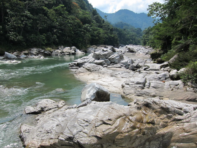
We took a few more photos then headed for Puyo, a small town of 25,000 where we found a room in a hostel for $20. After dinner a young guy from next door to the hostel came over to offer to guide us on a tour the next day. It sounded pretty good so we planned to meet early in the morning for the 90 minute ride back to Misahualli on the Rio Napo. Hector didn't have a vehicle so he rode on the back of my bike. In Misahualli we met another guide who took us downriver in his boat to a couple of small villages. The first village had a bit of a zoo and museum and another guide there showed us around. We were only there about 45 minutes or so which seems ridiculous. It's pretty cursory considering the subject matter. I could spend a week looking around just in that little village. It was still pretty interesting and the guide showed us some of the local wildlife they had there as pets. He also told us a bit about some of the plants they use for medicine and showed us around their museum of native (sorry...indigenous) artifacts. Next, we went back up the river to another village where the locals did a dance for us and the shaman cleansed us. They also  fed us an awesome lunch of fish, rice and some kind of plantain. I felt kind of silly watching the dance and taking the cleansing. It's not like your actually taking part. You're just getting the tourist show.
Our boat on the Rio Napo.

Shooting the rapids.

Neils little buddy.

These were all over the place. Pretty cool.

They said this was a type of jaguar. It was a young one and still wanted to suckle on the guides finger.

A little less cute.

Neils cleansing only took a few minutes. They told me to make another appointment.

Our dance troupe

Yummy lunch.
Hector then had us back on the bikes for another hour ride to the end of a gravel road where he took us to an indigenous reserve that was run like a park. It was an awesome river and we went for a nice swim.
The end of the road.


We even spotted the rare Amazonian Albino Chicken.
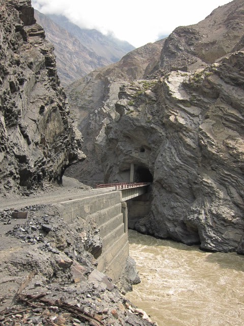
Today we left Puyo southbound on highway 45 to head back into the mountains. We don't have the greatest map (hey, it's not like we're going far) and we just ended up following some road signs to Cuenco. What could go wrong? We made a right turn at a little town called Mendez and ended up on this deserted crappy gravel road full of washouts and potholes and clinging to the mountainside thousands of feet above a raging river.
It was perfect.

I actually got butterflies a few times from looking over the side of the road. Holy Crap! It was a long way down.

It amazes me how much of the land is occupied and cultivated.

It doesn't matter where you are, you can still flag down a bus.
Hopefully we'll be in Vilcabamba, south of Loja, tomorrow (Thursday) night.
Bye for now.